


 wider area
of old Edmonton Edmonton
old town Silver Street Edmonton large houses Edmonton cinemas
in old Edmonton then and now Edmonton old rural Edmonton the windmill Edmonton old
Edgware

Old Edgware
The word Edgware brings to mind the old Roman Road, Watling Street, today called the Edgware Road which links the town of Edgware to London’s Marble Arch and is a main thorougfare. This page, though, is concerned with the town and its wider area in the mid-20th Century when I grew up there and when it was in the county of Middlesex. The page describes the two main streets, the suburban development and interesting features of the extension to the Northern Line of the London Underground which was started in the 1930s, interrupted by WW2 and never completed.
____
By the webmaster: her early recollections with further research and contributions from others who lived at the time
Edgware was in the county of Middlesex and the borough of Hendon for most of the 20th Century, but in 1965 it became part of Greater London for administrative purposes, mainly under the London Borough of Barnet but with small parts falling in the London boroughs of Harrow and Brent. Middlesex ceased to exist as a county, although its name lingers on in various older establishments.
Edgware High Street
The High Street was - and still is - the older part of Edgware and was part of the old Roman Road of Watling Street. I remember it from the 1940s when my mother dragged me to the antique shop just behind the lamppost in the following photograph and then took me aside to the pond in Cannons Drive to feed the ducks. Further along Cannons Drive was the George V Memorial Garden where she spent a lot of time just lost in admiration.
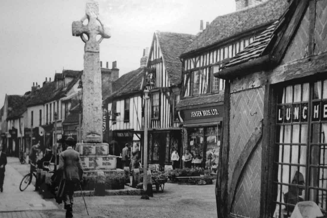
Edgware High Street about 1950 viewed from the war memorial - courtesy of Maureen Schiller. See how old the buildings look.
The Handel Smithy of 'The Harmonious Blacksmith' fame of the High Street
An interesting feature is the building known as the Handel Smithy which is on the right of the photo. The story goes that the composer Handel sheltered there from the rain when it was a smithy and was inspired by the sound of the hammer on the anvil to write The Harmonious Blacksmith. For more on this story - which is apparently only a story - see https://en.wikipedia.org/wiki/The_Harmonious_Blacksmith. The man reputed to be the blacksmith is buried in St Lawrence Church, Edgware, with its beautiful and colourful Baroque interior which, when I was a child, took my breath away.
Behind the Handel Smithy is what was then a dress factory, owned by the parents of Maureen Schiller who donated the photo.
The photo also shows Jenson Brothers shop, which looks to be a florist.
My first school, Edgware Primary School was also in the High Street, but further along on, the far side of the cross-roads with Station Road.
Looking today at Google Maps, I wonder if some of the road names have changed.
Station Road, Edgware
Station Road is a main road off the High Street. It probably got its name from the station for the old railway which ran coal fired goods trains, but which fell into disuse sometime in the 1940s or early 1950s.
Today, Station Road is the home of Edgware Station at the northern end of the London Underground's Northern Line. The station was opened on 18 August 1924 and became surrounded with typical 1930s suburbia including the road of suburban houses where I grew up and the typical small shops shown in the following photos.
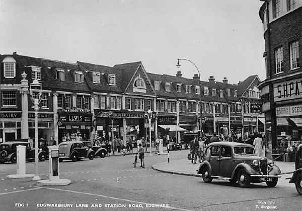
The Edgware shops about 1950 viewed from Edgwarebury Lane looking towards Station Road towards the station - from an original postcard which I bought in the 1950s. Earlier, in wartime, the road was much more empty and the only males to be seen were normally children or older men.
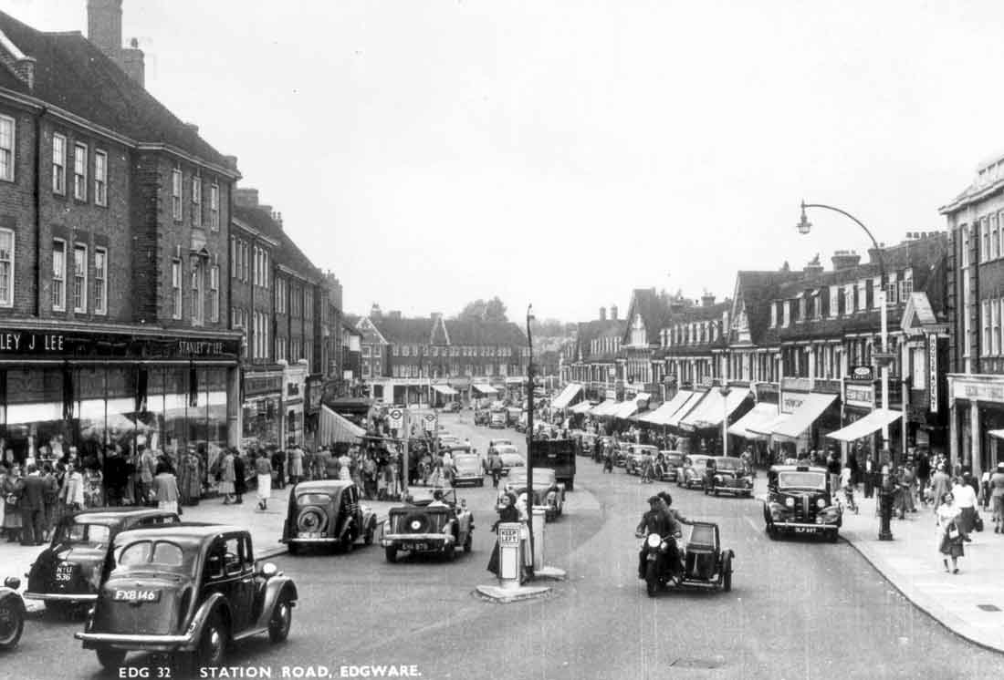
The Edgware shops about 1950 viewed from Edgware station looking along Station Road towards Edgwarebury Lane - from an original postcard which I bought in the 1950s. Again, in wartime the road was much less busy and the only males to be seen were normally only children or older men.
The proposed Northern Line extension from Edgware Station
It was never intended that Edgware should be the terminus for the Northern Line. The planned extensions did start, and were responsible for the interesting features described below. They were never completed because the building work was interrupted by the onset of the Second World War in 1939. After the war, plans changed.
The interesting features are described below. I wonder if they are still there. If you know, please contact me.
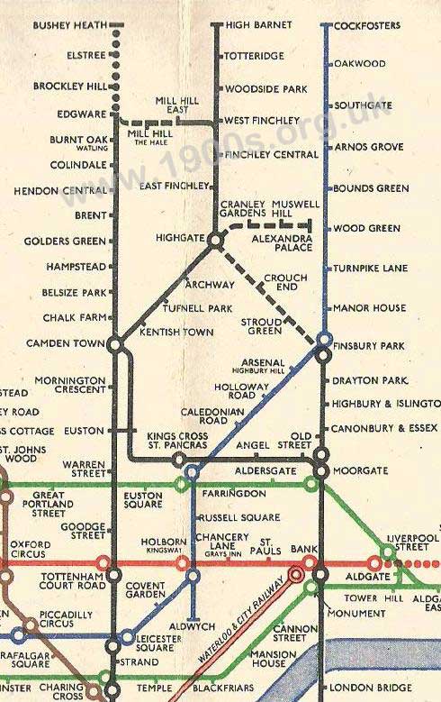
Section from the pocket book version of the 1946 London Underground map, issued by London Transport and showing the then envisaged extensions to line. Initially, the northern extension had been intended to go all the way to Watford. Scan is courtesy of Darren Kitson.
The extra platform at Edgware Station
There was one feature of Edgware station which always puzzled me as a child. As we came through the ticket barrier towards the trains, there was a flight of stairs on the right leading to a platform that never seemed to be used.
Only much later did I learn that this platform had been built to serve the extensions, and that Edgware had been set to become a junction station for lines to Bushey Heath and to Mill Hill East. This platform was to service these lines. In fact Edgware came very close to having a choice of three tube routes into central London - but that is another story.
Tunnels under Edgware
Another feature of the interrupted extensions to the Northern Line at Edgware were some partially completed tunnels under Station Road. Because Edgware station was to be a junction for a line to Bushey, tunnels were partially bored beneath Station Road and Rectory Lane. They certainly remained until 2014, possibly later.
In fact, Rectory Lane would not have existed had it not been for the abortive tube extension. During the 1920s the area west of Station Road was essentially open land and access was needed by the contractors to construct the tunnels beneath Station Road. So an access road, or 'service road', was created using the, then, open land. It was this contractors' access which later became Rectory Lane.
Construction of the tunnels involved installing a concrete raft to support buildings on Station Road while the tunnels were bored beneath. For the same reasons as work on the rest of the Northern Line extension was stopped, these tunnels were never completed, but they were visible from Edgware station's platforms 2 and 3.
During the Second World War, the abandoned tunnels were used as Edgware station's air raid shelter. Unfortunately, I never saw this myself because my family had our own Morrison shelter at home nearby.
Part of one of the tunnels was apparently used as a vault for Edgware's Abbey National branch which rented the space from London Transport.
Beyond Edgware station, the tunnels turned somewhat towards the northwest and passed beneath what became Nando's on Station Road. Continuing beneath Rectory Lane, the tunnels were to have emerged into a cutting. Some evidence of this remained on Rectory Lane in the form of a rather incongruous wall which was to be the parapet for the tunnel mouth, where the tracks would emerge from the tunnels into what would have been a cutting.
The brick arches along the A41
There was another interesting feature of the interrupted London Tube extensions. It was in the form of a then noteworthy landmark. Coming out of Edgware and turning left (west) onto what was then known as the Edgware Bipass and now as Edgware Way was a set of large and clearly unfinished brick-built arches in fields on the right.
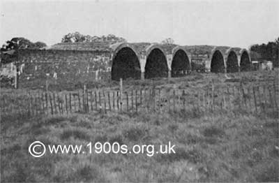
The brick arches in Edgware, built for the continuation of the Northern Line Underground but never completed. Photo courtesy of Roland Crisp.
These arches were part of the Edgware/Brockley Hill/Elstree/Bushey Heath extension which was to be overground and carried on viaducts. Brockley Hill station was to have been perched upon the viaduct.
The arches as a children's play area
We called these arches the 'Norman Castles', and we would spend hours climbing up and down them. In fact the whole area became our extended playground. It was amazing that none of us was ever injured.
Christine Tolton, formerly Christine Culley
Openings to the twin tunnels for the Elstree extension
As a local, I remember the arches and the embankment that follows northwards to the openings to the twin tunnels for the northbound into Elstree extension. The following photo shows them almost entirely under water. They are, now under the M1.
I also seem to recall a bridge over the A41, south of the arches that was later demolished. I believe the southern retaining wall might still exist.
Roland Crisp
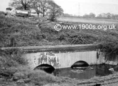
Part of the build for the Northern Line extension which was never completed: openings to the twin tunnels of the Elstree extension. Photo courtesy of Roland Crisp.
Plans for the extension after the war
London Transport had every intention of completing the Bushey Heath extension once the war was over, but more urgent matters meant the scheme was put on hold. Then came the so-called Green Belt legislation which put an end to the housing development beyond Brockley Hill which London Transport was hoping for in order to provide passengers for the new line.
Thus in 1950 the Bushey Heath extension was formally abandoned. Yet a possible extension from Edgware to Brockley Hill was never totally written off. Should it be built, it would now have to be entirely underground and at a cost which would probably be impossible to justify. Edgware station is likely, therefore, to remain a terminus.
Interesting asides
The above London Transport map gives the name of one of the proposed stations as Elstree, but it is believed that the name displayed on the actual station was to be changed to Elstree South. Apparently this was to distinguish it from Elstree and Borehamwood station which was some distance away to the north.
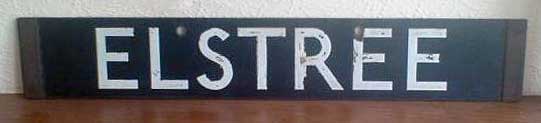
London Transport plate for display on the front of trains that would have terminated at Elstree. Plate in the possession of Darren Kitson.
Brockley Hill station was originally to be called Edgebury, and surviving early plans show it as such.
Although the station at Mill Hill (The Hale) never saw a tube train, London Transport did issue tube tickets to it. Strange? No, not really. The tickets included use of a connecting bus service between Mill Hill East and Edgware.
Aerial photographs
On the website www.britainfromabove.org.uk, two aerial images in particular relate to the proposed Northern line extension from Edgware.
Aerial view EPW016513 is taken from the north-west in 1926 and shows Edgware Tube Station and some of the new buildings on the other side of Station Road opposite the Station Entrance. The concrete raft to support the building work in Station Road immediately above the proposed northwards extension tunnel section is clearly seen as is also part of the access road, later Rectory Lane, behind these buildings.
A second aerial view EAW020694 taken from the south-west in 1948, shows the post war view of Edgware Tube station and roads and housing stretching northwards. To the upper right can be discerned the route of the A41/ Watford Bypass/ Edgware Way and a white streak along the proposed line route - presumably this white streak is the line of supports on each side of the Edgware Way for the proposed viaduct to carry the tube train route to the proposed Brockley Hill Station (about 500 yards east of the Canons Corner junction of Brockley Hill A5).
Edgware's Bletchley Park connection
Further onwards in a northerly direction to the site of the proposed Elstree South Station. Just to the right of centre and towards the top of the picture is a large complex of buildings situated at the bottom of Brockley Hill, which during the war was an important outstation for Bletchley Park, performing a large amount of Enigma key identification - the essential first step leading to successful decryption of an encrypted Enigma message - with reportedly in the region of 50 to 75 of the so-called Bombe machines. Its involvement in WW2 code breaking was to be secret until after the mid-1970s when information about Bletchley and its outstations was gradually published. It was known as the Stanmore Outstation and the area occupied just borders onto the Edgware area at Canons Corner, where its main entrance was situated.
Dave Waller
If you can add anything to this page or provide a photo, I would be pleased if you would contact me.
Text and images are copyright
sources: early 20th century material
sources: ww2 home front and other material
contact
the webmaster/author/researcher/editor
privacy policy

